Here you find useful information about how can satellites address a variety of different applications using different orbit alternatives.
Please note that those are 3rd party public content (ESA, NSS etc) available from YouTube.
They are shown in here just to make it easier for a quicker understand of key orbit alternatives and its related applications in the satellite service portfolio.
From National Security Space Institute, USA.
ORBIT TYPES :
YouTube : https://www.youtube.com/watch?v=BvjlBpP4zU8
COEs – Classical Orbit Elements :
YouTube : https://www.youtube.com/watch?v=2gAYqtmNJx8
KEPLER´s LAWS :
YouTube : https://www.youtube.com/watch?v=djgPfNrEkp0
Difference in between GEOSTATIONARY and GEOSYNCHRONUS orbits :
YouTube : https://www.youtube.com/watch?v=s6CeJs0UFqY
GEO – Geostationary Orbit
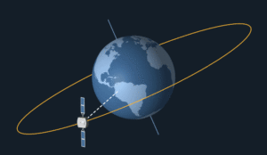
The goal of a geostationary satellite is to keep a continual watch on one specific area of the world. By orbiting at the same speed that the earth rotates (it is necessarily done over the equator), and at a constant distance of ~35,765 km altitude, such satellites stay always facing the same place on earth surface. This is called a geosynchronous orbit.

Video showing a geostationary orbit.
MEO – Medium Earth Orbit
MEO systems, instead, orbit the earth at the altitude of 10400 km, completing one round every 6 hours. Therefore, and unlike geostationary ones, satellites placed at this orbit move with respect to the earth.
LEO – Low Earth Orbit
https://www.sciencedirect.com/topics/earth-and-planetary-sciences/low-earth-orbit
LEO systems, instead, orbit the earth at altitudes ranging from about 700 to 2000 km. Therefore, and unlike geostationary ones, satellites placed at this orbit move with respect to the earth. A typical LEO satellite orbits the earth in less than two hours, which means that a satellite is in view for only a few minutes per orbit.
Because of this, users of LEO satellite services must be “handed off” from satellite to satellite as well as between “cells” within the footprint of a given satellite, in order to maintain the continuity of its communication.
The handoff between cells of a particular satellite is usually accomplished within the satellite itself; however, handoffs between satellites requires either the intervention of a ground terminal or communication between the satellites using crosslinks or some hybrid of these two approaches. Also, because of the relative velocity between a satellite and any particular point on the earth, Doppler is present on each of the communication links. In most cases, this Doppler effect must be corrected for in the earth terminal equipment.
The choice of altitude for a LEO constellation is usually governed by the cost of placing satellites at the particular altitude selected. The higher the altitude, the fewer the number of satellites required to obtain complete earth coverage. However, it is usually more costly to launch satellites to higher altitudes.
LEO satellites have a circular (or elliptical) orbit at a height of 250–2000 km from the Earth surface. The orbit period, mainly depending on the altitude, varies in the range 90–120 min. As the altitude of LEO satellites is low, their velocity is very high (>25,000 km/h) and they make 12–16 Earth turns per earth day. It means that a LEO satellite experiences at least 12 to 16 sunlight and night periods in 24 h.
Consequently, in LEO orbit, the maximum time during which a satellite is above the local horizon for an observer on the earth is up to 20 min. This time is used to transfer data payload, images and so on, towards selected ground stations positioned in strategic locations.
LEO satellites can have orbits inclined 0–90° vs. the equatorial plane, and inclination induces slight difference in the eclipse time. Considering an altitude of 650 km, the maximum eclipse time is close to 35 min.
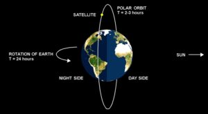
When the satellite orbit is inclined at ∼90° to the equatorial plane, it is called a polar orbit (covering both poles). It is characterized by long periods with no eclipse at all as per the solstice periods for the GEO satellites.
POLAR orbit

© copywright
A polar orbit is fixed in space, and the earth rotates underneath. Therefore, a single satellite in a polar orbit provides in principle coverage to the entire globe, although there are long periods during which the satellite is out of view of a particular ground station. This may be acceptable for a store-and-forward type of communication system. Accessibility can of course be improved by deploying more than one satellite in different orbital planes. Most small-LEO systems employ polar, or near-polar, orbits.
The polar satellites are able to repeatedly scan the complete round of the planet, several times per day, as they let Earth do the hard work. Earth rotates under these satellites as they move from pole to pole. These satellites have very low orbits, allowing them to travel around the world very quickly—sometimes as fast as once every hour and a half. The combination of the fast speed and the rotating Earth will make it possible for a polar satellite to fully see the weather around the entire planet every day.
Satellites in LEO are affected by an atmospheric drag that makes the orbit deteriorating gradually. Hence, the typical lifetime of a LEO satellite is 7–10 years.
Most of the LEO satellites are used for Earth or space observation and science. Examples of early LEO satellites are the Hubble space telescope, the Spot family of satellites (Earth imaging and survey) and military observation satellites.
Big LEO global communication systems, also called LEO constellations, such as Globalstar™ and Iridium™, provide a mobile communication system using a net formed by a huge number of satellites (up to 90 positioned in few orbit plans). These communication systems use this type of orbit mainly due to the low propagation delay (20–30 m) of the signal.
SSO orbit
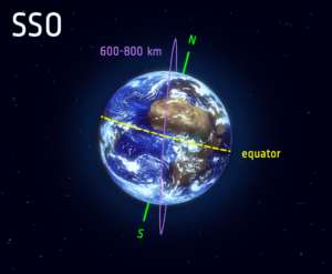
This video from ESA (European Space Agency) contains explanation for orbit types that better fit Earth observation, and how imaging applications can benefit from SSO:

A Sun-synchronous orbit (SSO), also called a helio-synchronous orbit, is a nearly polar orbit around a planet, in which the satellite passes over any given point of the planet’s surface at the same local mean solar time. More technically, it is an orbit arranged so that it precesses through one complete revolution each year, hence it always maintains the same relationship with the Sun.
A Sun-synchronous orbit is useful for imaging, reconnaissance satellite and weather satellites, because every time that the satellite is overhead, the surface illumination angle on the planet underneath will be nearly the same. This consistent lighting is a useful characteristic for satellites that image the Earth’s surface in visible or infrared wavelengths, such as weather and spy satellites; and for other remote-sensing satellites, such as those carrying ocean and atmospheric remote-sensing instruments that require sunlight. For example, a satellite in Sun-synchronous orbit might ascend across the equator twelve times a day each time at approximately 15:00 mean local time.
Polar orbit coverage completion. Animation on YouTube:
https://www.youtube.com/watch?v=y_jM_BxQGvE
SSO Polar Orbit. Animation on YouTube:
https://www.youtube.com/watch?v=tOp1UYbmp0Y
SSO orbit perspective. Animation on YouTube:
https://www.youtube.com/watch?v=ylvgxNF3C0c
Special cases of the Sun-synchronous orbit are the noon/midnight orbit, where the local mean solar time of passage for equatorial latitudes is around noon or midnight, and the dawn/dusk orbit, where the local mean solar time of passage for equatorial latitudes is around sunrise or sunset, so that the satellite rides the terminator between day and night.
Riding the terminator is useful for active radar satellites, as the satellites’ solar panels can always see the Sun, without being shadowed by the Earth. It is also useful for some satellites with passive instruments that need to limit the Sun’s influence on the measurements, as it is possible to always point the instruments towards the night side of the Earth. The dawn/dusk orbit has been used for solar-observing scientific satellites such as Yohkoh, TRACE, Hinode and PROBA-2, affording them a nearly continuous view of the Sun.
For more information on related business opportunities, please check it out for the USE CASES below:
USE CASE “CUBESATs”
USE CASE “NB-IoT”
USE CASE “OFFSHORE & MINING TELEMEDICINE”
USE CASE “REMOTE MINING”
Please, also check it out for the other KEY ON-GOING BUSINESS CASES at Brazilian Air Force (FAB):
BUSINESS CASE FAB / TELEBRAS “SGDC-1 / SGDC-2 plus TT&C COPE”
BUSINESS CASE FAB / AEB “ALCANTARA launching base”
BUSINESS CASE INPE REMOTE SENSE SATELLITE “CBERS”
BUSINESS CASE INPE REMOTE SENSING SATELLITE “AMAZONIA-1”
Please, also check it out for the KEY ON-GOING BUSINESS CASES at Brazilian Navy:
BUSINESS CASE MB “UNMANNED AIRCRAFT”
BUSINESS CASE MB “ANTI-SHIP MISSILES”
BUSINESS CASE MB “TAMANDARÉ FRIGATES”
If your company is interest on opportunities such as those above, please let us know. MEREGE would be more than glad to act as your bridge into Brazil.
Unfolding relationships previously developed, MEREGE partners were able to quickly build a specific network that would permeates the capillarity of aerospace sector.
MEREGE Legal & Regulatory team (LEGAL SERVICES PAGE), has a long and vast knowledge and experience, hence able to help your company to set the safest and the strongest path to this promising market.
Always count on the widely respected experience and networking of MEREGE Consulting Partners to reach out to the right people at the right time.


